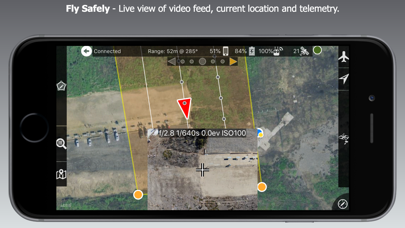
Map Pilot AG is based on the solid base of Map Pilot for DJI except it has a bunch of new features designed specifically for use with agricultural cameras.
Map Pilot AG uses flight patterns that are optimized for non-gimbaled cameras with fixed imaging intervals like the Sony MSZ-2100G (others coming soon).
Map Pilot AG is for use with Drones Made Easy Ag Kits only. Without physical access to hardware provided by Drones Made Easy it will not be possible to access the layout screen.
View Documentation: http://support.dronesmadeeasy.com
Ag Specific Features:
Sampling Mission Flights for accurate Stand Counts
Spot Check Flights for super high detail imaging
Safe Height flight selection
Shutter Cycle selection
Up and Over flight for safe low altitude surveying
Share missions directly from user to user
Import Farms and Fields from Farm Shots ag software
Import Boundaries from Maps Made Easy
Sync Missions with Maps Made Easy
Terrain Awareness
Multi-Battery Management
Basemap Caching for Offline Operations
Save/Edit Missions
Refly Saved Missions
Import KML via Email or AirDrop
Export KML, log files, and Flights file via Email or AirDrop
Flight Log review
Built-in Simulator for testing
Overlap Management
Speed Management
Automatic Takeoff and Landing
Live Video Preview (large and small)
Signal Quality Warning
Line of Sight Indicator
Live Map View
Compatible with iOS 13.
Supported Aircraft:
Mavic 2 (Pro, Zoom, and Enterprise)
Phantom 4 Pro * (v2 included)
Phantom 4 Advanced
Inspire 2
Matrice 200 (M200)
Matrice 210 (M210)
Matrice 210 RTK (M210RTK)
Matrice 600 (M600)
Matrice 600P (M600P)
Supported External Cameras:
DJI X7
DJI X4S
DJI X5S
Sony Multispectral Camera (MSZ-2100G) as part of the Drones Made Easy and Sony Smart Agriculture Solution
* Phantom 4 Pro v2 is supported. Phantom 4 Pro Plus version is not supported.


